Source: The Star
Rio de Janeiro was hit by floods around this time last year, which left 903 people dead. The same happened in April the year before in 2010. This year again, news around the world is reporting floods and mudslides in Brazil's Rio de Janeiro state.
Emergency teams are on maximum alert as heavy rains that have displaced 35,000 residents were forecast to continue, reviving fears of mudslides and flooding that killed more than 900 people early last year.
Related articles:
Brazil is flooded once more.. Aljazeera
Part of a highway in Campos, 230km from Rio de Janeiro, was washed away after several days of heavy rains [Reuters]
Burst dike forces thousands to flee Brazil town..MSNBC
A girl stands on the top of the roof of her house, where her family has gathered belongings in Campos, Rio de Janeiro State, after floodwaters burst a nearby dike on Jan. 5, 2012. Leonardo Berenger/Parceiro / AFP - Getty Images
4,000 Brazilians evacuated as dike bursts after heavy rains..CNN
People watch water run through a washed-out road Thursday in Brazil's Rio de Janeiro state
According to The Star,
Residents scrambled to gather their belongings and flee in the Tres Vendas district of Campos de Goytacazes in the north of the state, after a dike ruptured, sending water rushing through the streets.
Emergency workers said more than 1,000 families from Tres Vendas were evacuated to shelters. More..Rio de Janeiro on maximum alert as towns flood
A video posted by Reuters of the flooding so far.
Rio de Janeiro will be hosting two major football tournaments - the FIFA Confederations Cup 2013 and the 2014 FIFA World Cup.
Showing posts with label natural disasters. Show all posts
Thursday, January 5, 2012
Wednesday, January 4, 2012
Kuching hit by massive floods
Here we are talking about the beautiful weather here in Kuala Lumpur while over in East Malaysia, Kuching to be exact, we see floods after 12 hours of continuous rain. Many parts of Kuching in Sarawak are at a standstill today.
A car is caught in flood waters near the former government quarters area in Batu Lintang. Photo by Andrew Voon.
From The Star:
The affected areas include Batu Kawah, Batu Lintang, Sungai Maong, Iris Garden and Satok. Many roads are impassable to small vehicles.
At the flyover from the Kuching international airport, motorists reported that all four lanes heading towards the city are jammed.
At least one school in Batu Lintang is believed to have closed for the day due to flood waters.
It is learnt that two students from a school in Batu Lintang are missing due to the floods. A search for the students is now being conducted.
A car is caught in flood waters near the former government quarters area in Batu Lintang. Photo by Andrew Voon.
From The Star:
The affected areas include Batu Kawah, Batu Lintang, Sungai Maong, Iris Garden and Satok. Many roads are impassable to small vehicles.
At the flyover from the Kuching international airport, motorists reported that all four lanes heading towards the city are jammed.
At least one school in Batu Lintang is believed to have closed for the day due to flood waters.
It is learnt that two students from a school in Batu Lintang are missing due to the floods. A search for the students is now being conducted.
Sunday, December 18, 2011
Typhoon Washi hit Southern Philippines causing flash floods killing 650
800 people are reported missing in southern Philippines on Sunday (today) after houses were swept into rivers and out to sea by flash floods and landslides caused by Typhoon Washi that hit the area.
Cagayan de Oro and nearby Iligan cities on Mindanao island were worst hit when Typhoon Washi slammed ashore while people slept late on Friday and early Saturday, sending torrents of water and mud through villages and stripping mountainsides bare.
Floods washed away entire houses with families inside in dozens of coastal villages in Cagayan de Oro and Iligan.
"This is the first time this has happened in our city," Vicente Emano, mayor of Cagayan de Oro, said in a radio interview. He said officials in the area did not receive adequate warning before the typhoon struck.
The death toll has reached 650 and thousands have been made homeless.
Source: The Star
- Philippines searches for hundreds after typhoon kills 650
Cagayan de Oro and nearby Iligan cities on Mindanao island were worst hit when Typhoon Washi slammed ashore while people slept late on Friday and early Saturday, sending torrents of water and mud through villages and stripping mountainsides bare.
Floods washed away entire houses with families inside in dozens of coastal villages in Cagayan de Oro and Iligan.
"This is the first time this has happened in our city," Vicente Emano, mayor of Cagayan de Oro, said in a radio interview. He said officials in the area did not receive adequate warning before the typhoon struck.
The death toll has reached 650 and thousands have been made homeless.
Source: The Star
- Philippines searches for hundreds after typhoon kills 650
Wednesday, December 14, 2011
Kuala Lumpur hit by flood again - Dec 14 2011
Kuala Lumpur was again hit by floods in various parts of the city after a heavy downpour this afternoon. Affected areas included Raja Chulan, the Pudu area, Jalan Tun Razak (again) and Jalan Sultan Ismail, and the basement car park of Sungei Wang Plaza was submerged in ankle-deep water.
Image source: The Star
Tuesday, December 13, 2011
Flash floods hit Kuala Lumpur Dec 13 2011
This is Jalan Tun Razak being flooded yesterday.
If not for the caption in the article, I wouldn't have been able to tell where this place is. Flooding changes a whole landscape.
Heavy rain yesterday just for a couple of hours caused Sungei (River) Bunus to overflow and thigh-high floodwaters cut off traffic along Jalan Tun Razak causing massive traffic jams during the evening peak hours. This stretch is in front of the national library which is also where the National Heart Institute (IJN) is located on the opposite side.
Floodwaters reached chest level according to a nursery school teacher. Some 23 children were all ushered to the second floor and were later rescued by boat by rescue team from the Fire department. 20 students of a multimedia college located next to the nursery were also evacuated.
Many vehicle drivers abandoned their vehicles and waded out.
However, all roads were accessible after the flood waters subsided at 7pm.
Source: The Star.. Over 20 nursery children rescued in KL flash floods
If not for the caption in the article, I wouldn't have been able to tell where this place is. Flooding changes a whole landscape.
Heavy rain yesterday just for a couple of hours caused Sungei (River) Bunus to overflow and thigh-high floodwaters cut off traffic along Jalan Tun Razak causing massive traffic jams during the evening peak hours. This stretch is in front of the national library which is also where the National Heart Institute (IJN) is located on the opposite side.
Floodwaters reached chest level according to a nursery school teacher. Some 23 children were all ushered to the second floor and were later rescued by boat by rescue team from the Fire department. 20 students of a multimedia college located next to the nursery were also evacuated.
Many vehicle drivers abandoned their vehicles and waded out.
However, all roads were accessible after the flood waters subsided at 7pm.
Source: The Star.. Over 20 nursery children rescued in KL flash floods
Sunday, December 4, 2011
Freak storm and strong winds caused more flooding yesterday
Freak storm and strong winds yesterday wreaked havoc across the Klang Valley resulting in flash floods and trees being uprooted damaging property.
This image shows vehicles negotiating floodwaters over a stretch of the Damansara-Puchong Highway in Puchong.
Bumper-to-bumper traffic along Jalan Tun Razak in Kuala Lumpur.
On the east coast, Kuantan was not spared either as several areas in the state capital of Pahang were hit, areas which do not normally experience floods.
Malaysians have been urged to brace for the worst in anticipation of weather pattern changes.
Meanwhile, Kajang is recovering from the flood which stuck this town south of Kuala Lumpur on Friday when torrential rain broke the riverbank causing flood waters to rise rapidly flooding the town for three hours.
Source: The Star
This image shows vehicles negotiating floodwaters over a stretch of the Damansara-Puchong Highway in Puchong.
Bumper-to-bumper traffic along Jalan Tun Razak in Kuala Lumpur.
On the east coast, Kuantan was not spared either as several areas in the state capital of Pahang were hit, areas which do not normally experience floods.
Malaysians have been urged to brace for the worst in anticipation of weather pattern changes.
Meanwhile, Kajang is recovering from the flood which stuck this town south of Kuala Lumpur on Friday when torrential rain broke the riverbank causing flood waters to rise rapidly flooding the town for three hours.
Source: The Star
Friday, December 2, 2011
Kajang flooded for about three hours after torrential rain
Aerial view of the flood today. — Photo from Facebook/Malaysian Insider
Hours of torrential rain this afternoon caused the river to break its banks resulting in Kajang town being submerged under floodwaters with cars being swept aside. The town practically came to a standstill as waters rose to more than a meter. Water rushed into shopping complexes, shops and restaurants.
The streets began to flood at 3pm and by 6pm, floodwaters have subsided enough for cars to move.
Two videos below from The Malaysian Insider..
Images from The Star where you can also read more about the flood.
Hours of torrential rain this afternoon caused the river to break its banks resulting in Kajang town being submerged under floodwaters with cars being swept aside. The town practically came to a standstill as waters rose to more than a meter. Water rushed into shopping complexes, shops and restaurants.
The streets began to flood at 3pm and by 6pm, floodwaters have subsided enough for cars to move.
Two videos below from The Malaysian Insider..
Images from The Star where you can also read more about the flood.
Friday, November 25, 2011
Monsoon Floods worsen in Kelantan
As flood worsens in Kelantan caused by heavy downpour in this year-end monsoon season, more residents are being evacuated. A total of 2,345 people were still at flood relief centres in Kelantan and Terengganu on Saturday, The Star reported.
Although this number is small compared to the number in Bangkok, it nevertheless disrupts routines and causes inconvenience and hardship to the victims. The number of evacuees in Kelantan has risen to 1,884 but in Terengganu, the number has dropped to 461.
In Pasir Mas, a stretch at Km24 of the Pasir Mas-Rantau Panjang Highway is impassable to light vehicles.
For readers not familiar with the Malaysian landscape, note the kampong (rural/village) house in the second image. This is a typical house in rural parts across the country. The elevated nature of these houses is a big help in the event of floods. In a village setting, free-range chickens and other fowl are a common sight under the house or running around in the compound. Being made of wood, these houses, usually big, are airy and cooling.
Source: The Star
Although this number is small compared to the number in Bangkok, it nevertheless disrupts routines and causes inconvenience and hardship to the victims. The number of evacuees in Kelantan has risen to 1,884 but in Terengganu, the number has dropped to 461.
In Pasir Mas, a stretch at Km24 of the Pasir Mas-Rantau Panjang Highway is impassable to light vehicles.
For readers not familiar with the Malaysian landscape, note the kampong (rural/village) house in the second image. This is a typical house in rural parts across the country. The elevated nature of these houses is a big help in the event of floods. In a village setting, free-range chickens and other fowl are a common sight under the house or running around in the compound. Being made of wood, these houses, usually big, are airy and cooling.
Source: The Star
Monday, November 14, 2011
Bangkok flood situation - Nov 14
The Bangkok flood situation was our table-topic this morning at breakfast. I haven't paid much attention to the flood lately but looking it up again found that the situation is still a concern. Water level is still more than a meter high in the flooded areas.
(Source:earthobservatory.nasa.gov)
Bangkok Post reported that: City Hall has issued an evacuation order for 10 areas in Samae Dam sub-district of Bang Khun Thian district in western Bangkok's Thon Buri side as floods there have continued to rise.
The elderly, children and sick people are urged to leave immediately for designated shelters or other safe areas.
Overflow from Khlong Maha Sawat and Khlong Phasi Charoen caused the water level in those areas to rise rapidly. More..Evacuation order issued in Thon Buri
Meanwhile at Don Muang, Don Muang residents removed more of the "big bags" forming a floodwall on Vibhavadi Rangsit Road despite the prime minister's insistence that the barrier must stand.
About 40 residents helped to manually move the 2.5-tonne bags. Protest Leader, Mr Thinnakorn, insisted pulling the big bags away was to release some of the floodwater that has been trapped in more than 20 housing estates and to allow boats used by residents to get through. The removal of the bags was carried out in the presence of senior police from Don Muang police station.
On the other hand, according to Pracha Promnok, director of Flood Relief Operations Command (Froc), the barrier is helpful as it slows water flowing into Bangkok through upper districts.
At the same time, many more water pumps have been deployed to hasten drainage. Read Don Muang bags protest grows
I have got here a video that allows us to have an aerial view of the flooding in Bangkok.
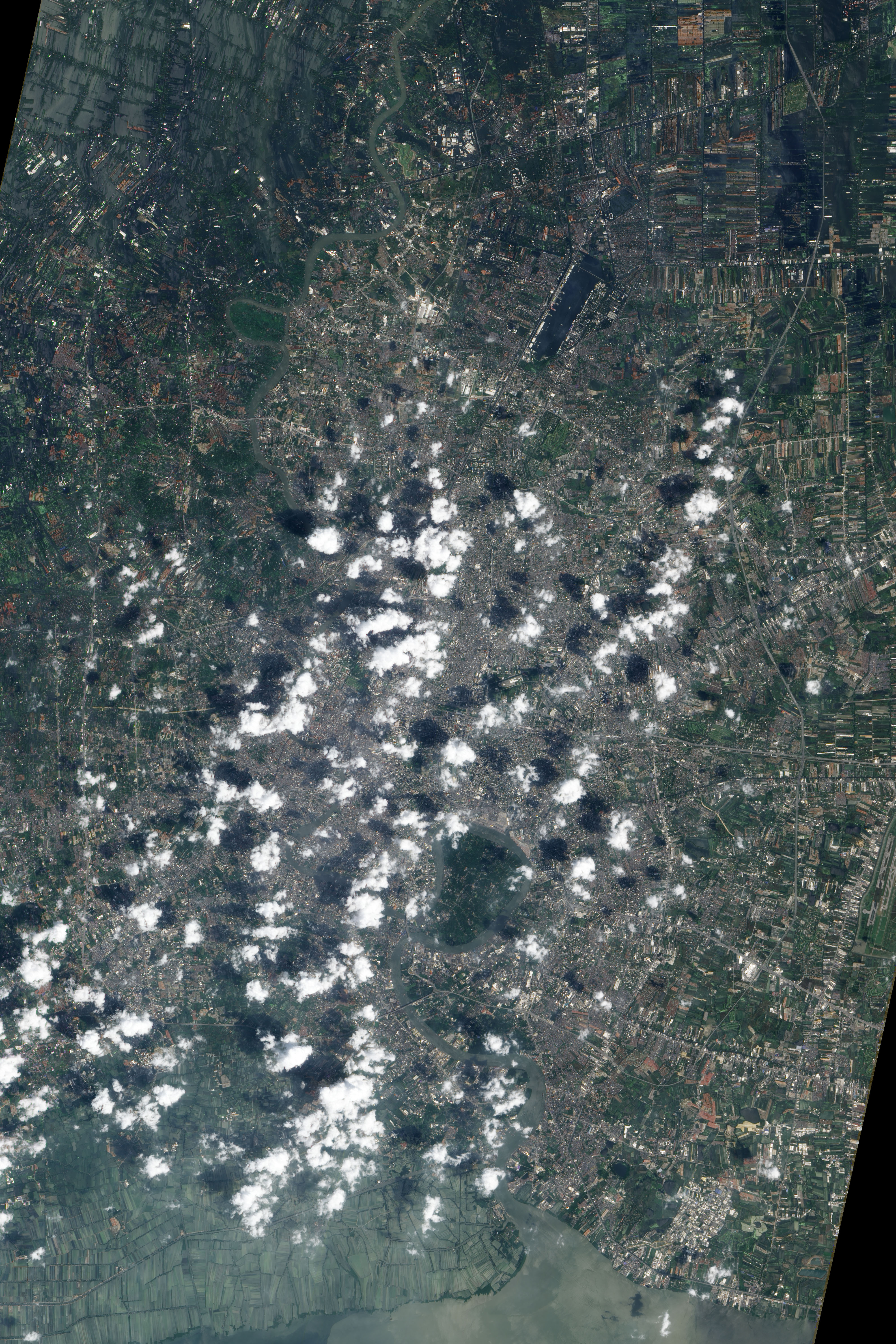
And here is an image taken by the Advanced Land Imager (ALI) on NASA’s Earth Observing-1 (EO-1) satellite. Image was taken on October 29, 2011.
Flood waters inundate Bangkok's domestic airport at Don Muang where flooding is most obvious, but much of the area in the image is flooded. The spaces between buildings and under trees are blue. Signs of flooding are also evident throughout the large image, which includes a much wider area.
The Don Muang Airport, a domestic airport, stopped operations after the runways flooded on October 25. However, the building housed the Flood Relief Operating Center and some 4,000 flood evacuees. The evacuees were forced to leave on October 25, and the Flood Relief Operating Center moved on October 29 when the building flooded. The airplanes shown in the image were decommissioned before the flood. Bangkok’s primary airport, Suvarnabhumi, is still operating and is expected to stay dry.
(Source:earthobservatory.nasa.gov)
Some good news as well. Recovery and clean-up work have begun at four flood-hit industrial estates in Ayutthaya as water in several parts of the central province has receded. They are Rojana, Hi-Tech, Bang Pa-in and Factory Land industrial estates.
Factory Land is almost dry as 80% of the estate has been drained. Of the estate's 93 manufacturing plants, 12 have resumed full operations while clean-up work is under way at the remaining plants.
More..Recovery, clean-up starts at four Ayutthaya estates
If you are still thinking about going to Bangkok, here is more information which may be of interest:
According to The Examiner:
Travelers from the US to Bangkok beware! The ongoing flood waters have nowhere to go in Bangkok, where over 5 feet of rain fell since March. Pacific coast travelers need to know that subways, garbage and travel are seriously affected including the Grand Palace and Safari World. Normally, only 40 inches of rain fall in Bangkok. Even worse, this water is trapped with no end in sight. California residents and travelers with travel vacation plans to Asia will want to skip Bangkok for the near future.
More..Bangkok flood spreads to subways, garbage piles up under 5 feet of rain
From CNNGo:
Most major tourism attractions in Bangkok still dry but situation remains uncertain
Mixed messages from Thai government and Bangkok officials continue to leave locals uncertain about when the city's flood situation will be resolved, as waters continue to sweep through parts of the city.
As of Monday most major tourist areas in central Bangkok, such as Sukhumvit Road, Siam and Silom, are still dry. Shopping malls, bars and restaurants in those areas are open, while most major hotels are operating as usual, including those on the Chao Phraya River.
More..Thai flood crisis: Updated info for tourists
And finally, a future concern? Will Thailand flooding be a major obstacle to contend with in the years to come?
The Thai capital, built on swampland, is slowly sinking and the floods currently besieging Bangkok could be merely a foretaste of a grim future as climate change makes its impact felt, experts say. - Floods Show What Lies Ahead for Sinking Bangkok
Related posts:
Bangkok flood situation Nov 7 Suvarnabhumi Airport is dry and fully operational
Bangkok flood - Pictures
Bangkok flood situation Nov 5
Further updates on Bangkok flood situation, Nov 1
Bangkok flood situation update - October 29 2011
Should you cancel your trip to Bangkok?
Thailand flood situation and getting updates via social media
(Source:earthobservatory.nasa.gov)
Bangkok Post reported that: City Hall has issued an evacuation order for 10 areas in Samae Dam sub-district of Bang Khun Thian district in western Bangkok's Thon Buri side as floods there have continued to rise.
The elderly, children and sick people are urged to leave immediately for designated shelters or other safe areas.
Overflow from Khlong Maha Sawat and Khlong Phasi Charoen caused the water level in those areas to rise rapidly. More..Evacuation order issued in Thon Buri
Meanwhile at Don Muang, Don Muang residents removed more of the "big bags" forming a floodwall on Vibhavadi Rangsit Road despite the prime minister's insistence that the barrier must stand.
About 40 residents helped to manually move the 2.5-tonne bags. Protest Leader, Mr Thinnakorn, insisted pulling the big bags away was to release some of the floodwater that has been trapped in more than 20 housing estates and to allow boats used by residents to get through. The removal of the bags was carried out in the presence of senior police from Don Muang police station.
On the other hand, according to Pracha Promnok, director of Flood Relief Operations Command (Froc), the barrier is helpful as it slows water flowing into Bangkok through upper districts.
At the same time, many more water pumps have been deployed to hasten drainage. Read Don Muang bags protest grows
I have got here a video that allows us to have an aerial view of the flooding in Bangkok.
And here is an image taken by the Advanced Land Imager (ALI) on NASA’s Earth Observing-1 (EO-1) satellite. Image was taken on October 29, 2011.
Flood waters inundate Bangkok's domestic airport at Don Muang where flooding is most obvious, but much of the area in the image is flooded. The spaces between buildings and under trees are blue. Signs of flooding are also evident throughout the large image, which includes a much wider area.
The Don Muang Airport, a domestic airport, stopped operations after the runways flooded on October 25. However, the building housed the Flood Relief Operating Center and some 4,000 flood evacuees. The evacuees were forced to leave on October 25, and the Flood Relief Operating Center moved on October 29 when the building flooded. The airplanes shown in the image were decommissioned before the flood. Bangkok’s primary airport, Suvarnabhumi, is still operating and is expected to stay dry.
(Source:earthobservatory.nasa.gov)
Some good news as well. Recovery and clean-up work have begun at four flood-hit industrial estates in Ayutthaya as water in several parts of the central province has receded. They are Rojana, Hi-Tech, Bang Pa-in and Factory Land industrial estates.
Factory Land is almost dry as 80% of the estate has been drained. Of the estate's 93 manufacturing plants, 12 have resumed full operations while clean-up work is under way at the remaining plants.
More..Recovery, clean-up starts at four Ayutthaya estates
If you are still thinking about going to Bangkok, here is more information which may be of interest:
According to The Examiner:
Travelers from the US to Bangkok beware! The ongoing flood waters have nowhere to go in Bangkok, where over 5 feet of rain fell since March. Pacific coast travelers need to know that subways, garbage and travel are seriously affected including the Grand Palace and Safari World. Normally, only 40 inches of rain fall in Bangkok. Even worse, this water is trapped with no end in sight. California residents and travelers with travel vacation plans to Asia will want to skip Bangkok for the near future.
More..Bangkok flood spreads to subways, garbage piles up under 5 feet of rain
From CNNGo:
Most major tourism attractions in Bangkok still dry but situation remains uncertain
Mixed messages from Thai government and Bangkok officials continue to leave locals uncertain about when the city's flood situation will be resolved, as waters continue to sweep through parts of the city.
As of Monday most major tourist areas in central Bangkok, such as Sukhumvit Road, Siam and Silom, are still dry. Shopping malls, bars and restaurants in those areas are open, while most major hotels are operating as usual, including those on the Chao Phraya River.
More..Thai flood crisis: Updated info for tourists
And finally, a future concern? Will Thailand flooding be a major obstacle to contend with in the years to come?
The Thai capital, built on swampland, is slowly sinking and the floods currently besieging Bangkok could be merely a foretaste of a grim future as climate change makes its impact felt, experts say. - Floods Show What Lies Ahead for Sinking Bangkok
Related posts:
Bangkok flood situation Nov 7 Suvarnabhumi Airport is dry and fully operational
Bangkok flood - Pictures
Bangkok flood situation Nov 5
Further updates on Bangkok flood situation, Nov 1
Bangkok flood situation update - October 29 2011
Should you cancel your trip to Bangkok?
Thailand flood situation and getting updates via social media
Sunday, November 6, 2011
Bangkok flood situation Nov 7 Suvarnabhumi Airport is dry and fully operational
More on Bangkok flood situation - Nov 7 update
According to Bangkok Post, images of a Thai Airways International Airbus stranded in deep floodwater at Don Mueang airport have caused misconceptions among many people outside Thailand that Bangkok is closed to air traffic.
Images like this could be driving away visitors to other destinations according to an airport official. The reality is, the main airport, Suvarnabhumi, is functioning.
Strong 3.5-metre-high polder dykes surrounding the airport constructed in 1995 and completed in 2000 are capable of preventing penetration of water. The dykes have made the airport a closed area, whereby water cannot flow in from the outside.
In addition,there is in place a high-standard water-management system, with drainage canals all around the site to drain water into the reservoirs plus two main pump stations, each equipped with four water pumps, with ability to drain water at a rate of 12 cubic metres per second or 1 million cubic metres per day.
Also, travel to and from the airport is unaffected as the roads and the Airport Rail Link tracks are elevated above the dykes.
In any case, some locals are of the opinion that now is not the time for people to be going to Bangkok as there are far too many problems still related to the floods, including the high possibility of disease breaking out. Clean-up will take months after the flood has receded.
How about an all-around view of a flooded part of the city? Here is an interesting 360-degree panoramic view of Kaset Intersection Bangkok Flood 2011 in Bangkok
Meanwhile, another zoo in the Bangkok area has been hit as floodwaters continue to swamp the city.
The 500-acre complex, Safari World, is the second Bangkok animal park to come under threat in recent weeks, after the city’s popular Dusit Zoo was forced to relocate some of its animals when floodwaters got too close. Safari World is located in a particularly vulnerable place, east of Bangkok’s shuttered Don Muang airport in an area of the city that has faced serious, ongoing flooding.
Parts of the complex have been hit by knee-high water, but staff have pushed the animals farther inside the zoo onto higher ground. Nevertheless, “we’re not evacuating,” Mr. Litti, the executive vice-president said. In many ways that would present more challenges than staying, he said, due to the logistical issues.
More on Wall Street Journal.. Another Bangkok Zoo Gets Hit By Flooding
Image sources:
- Bangkok Post
- Wall Street Journal
Related posts:
Bangkok flood situation - Nov 14
Bangkok flood - Pictures
Bangkok flood situation Nov 5
Further updates on Bangkok flood situation, Nov 1
Bangkok flood situation update - October 29 2011
Should you cancel your trip to Bangkok?
Thailand flood situation and getting updates via social media
According to Bangkok Post, images of a Thai Airways International Airbus stranded in deep floodwater at Don Mueang airport have caused misconceptions among many people outside Thailand that Bangkok is closed to air traffic.
Images like this could be driving away visitors to other destinations according to an airport official. The reality is, the main airport, Suvarnabhumi, is functioning.
Strong 3.5-metre-high polder dykes surrounding the airport constructed in 1995 and completed in 2000 are capable of preventing penetration of water. The dykes have made the airport a closed area, whereby water cannot flow in from the outside.
In addition,there is in place a high-standard water-management system, with drainage canals all around the site to drain water into the reservoirs plus two main pump stations, each equipped with four water pumps, with ability to drain water at a rate of 12 cubic metres per second or 1 million cubic metres per day.
Also, travel to and from the airport is unaffected as the roads and the Airport Rail Link tracks are elevated above the dykes.
In any case, some locals are of the opinion that now is not the time for people to be going to Bangkok as there are far too many problems still related to the floods, including the high possibility of disease breaking out. Clean-up will take months after the flood has receded.
How about an all-around view of a flooded part of the city? Here is an interesting 360-degree panoramic view of Kaset Intersection Bangkok Flood 2011 in Bangkok
Meanwhile, another zoo in the Bangkok area has been hit as floodwaters continue to swamp the city.
The 500-acre complex, Safari World, is the second Bangkok animal park to come under threat in recent weeks, after the city’s popular Dusit Zoo was forced to relocate some of its animals when floodwaters got too close. Safari World is located in a particularly vulnerable place, east of Bangkok’s shuttered Don Muang airport in an area of the city that has faced serious, ongoing flooding.
Parts of the complex have been hit by knee-high water, but staff have pushed the animals farther inside the zoo onto higher ground. Nevertheless, “we’re not evacuating,” Mr. Litti, the executive vice-president said. In many ways that would present more challenges than staying, he said, due to the logistical issues.
More on Wall Street Journal.. Another Bangkok Zoo Gets Hit By Flooding
Image sources:
- Bangkok Post
- Wall Street Journal
Related posts:
Bangkok flood situation - Nov 14
Bangkok flood - Pictures
Bangkok flood situation Nov 5
Further updates on Bangkok flood situation, Nov 1
Bangkok flood situation update - October 29 2011
Should you cancel your trip to Bangkok?
Thailand flood situation and getting updates via social media
Saturday, November 5, 2011
Bangkok flood in Pictures
If a picture is worth a thousand words, below are thousands about the flood in Bangkok or rather Thailand now. These images were received in an email and no source was quoted. I would like to credit the source so if you have information about the source, please let me know in the Comments.
And my favorite..A monkey helping a dog/puppy. Just look at the monkey's expression. Aww!
Meanwhile, the floods in Thailand are pushing up prices of fresh produce in the northern states of Malaysia including in Kedah. Prices of fish, red chillies and vegetables have increased sharply as a result of the floods in Thailand. Due to its proximity to the northern states, Thailand is the main exporter of these produce.
Red chillies are now going for between RM13 to RM15 a kg from RM8 to RM10 previously; RM3.50 for mustard (from RM2.50 previously), RM5 for tomatoes (RM4), RM5 for lime (RM3), RM3 for ladies' finger (RM1.50) and RM3.50 for cucumber (RM2). Source: The Star
Related posts:
Bangkok flood situation Nov 7 International Airport is dry and fully operational
Bangkok flood situation Nov 5
Further updates on Bangkok flood situation, Nov 1
Bangkok flood situation update - October 29 2011
Should you cancel your trip to Bangkok?
Thailand flood situation and getting updates via social media
And my favorite..A monkey helping a dog/puppy. Just look at the monkey's expression. Aww!
Meanwhile, the floods in Thailand are pushing up prices of fresh produce in the northern states of Malaysia including in Kedah. Prices of fish, red chillies and vegetables have increased sharply as a result of the floods in Thailand. Due to its proximity to the northern states, Thailand is the main exporter of these produce.
Red chillies are now going for between RM13 to RM15 a kg from RM8 to RM10 previously; RM3.50 for mustard (from RM2.50 previously), RM5 for tomatoes (RM4), RM5 for lime (RM3), RM3 for ladies' finger (RM1.50) and RM3.50 for cucumber (RM2). Source: The Star
Related posts:
Bangkok flood situation Nov 7 International Airport is dry and fully operational
Bangkok flood situation Nov 5
Further updates on Bangkok flood situation, Nov 1
Bangkok flood situation update - October 29 2011
Should you cancel your trip to Bangkok?
Thailand flood situation and getting updates via social media
Friday, November 4, 2011
Bangkok flood situation Nov 5
Read Latest update: Nov 14
Looks like the flood situation in Bangkok is still a concern, probably an understatement here. We have to be in the midst of it all to experience the hardship and frustration. I am not familiar with the road nor area names but to those who are, below would be more meaningful to you.
It is still heart-rending to see pictures of the floods, especially of the animals who are equally if not more stressed out - which reminds me, the pictures as mentioned earlier are coming up next. In the meantime, here is today's update on the flood situation..
Bangkok Post reported today that
The government's attempts to safeguard Lat Krabang and Bangchan industrial estates from the northern runoff were frustrated yesterday when more than 300 residents protested against the closure of Khlong 9 water gate in Pathum Thani's Lam Luk Ka district.
Below shows floodwaters filling the Lat Phrao-Phahon Yothin intersection yesterday, closing the Central Plaza department store and raising fears that the deluge is approaching inner Bangkok.
Some updates:
- The northern runoff has reached Lat Phrao intersection in Chatuchak district, disrupting businesses, residents and the Flood Relief Operation Command (Froc) headquarters nearby. Water level was measured at 60cm at midday yesterday and appeared to be rising. Residents and employees had to wade through knee-high water to flee flooded homes and workplaces.
- Part of Lat Phrao Road from Soi Lat Phrao-Wang Hin 87 to Lat Pla Khao Road was covered with about 30cm of floodwater.
- Floodwater levels in Senaniwes 1 and Senaniwes 2 housing estates and Wat Lat Pla Khao were measured at between 80cm to 1m. Evacuation order yesterday has been issued for these areas by Bangkok governor, Sukhumbhand Paribatra.
- After Lat Phrao, floodwater was expected to flow to Ratchadapisek Road and the wider Chatuchak area as the topography map shows that the two areas sit on low-lying zones, said Seri Supparathit, a Rangsit University expert on natural disasters.
Elsewhere in Bangkok, the deluge has expanded to larger areas in many districts. More..Protesters block sluice gate closure
With the floodwater raging south trying to reach the gulf, Rama II Road looks to be flooded.
A source at the Flood Relief Operations Command said officials had decided not to build barriers to stop water moving towards the road and will let it flow over it and continue to the Gulf of Thailand.
Rama II is the only lifeline available for motorists wanting to travel to the South or resort areas in the lower central provinces.
Read: Froc abandons Rama II Road
Source: Bangkok Post
Related posts:
Bangkok flood situation - Nov 14
Bangkok flood situation Nov 7 International Airport is dry and fully operational
Bangkok flood - Pictures
Further updates on Bangkok flood situation, Nov 1
Bangkok flood situation update - October 29 2011
Should you cancel your trip to Bangkok?
Thailand flood situation and getting updates via social media
Looks like the flood situation in Bangkok is still a concern, probably an understatement here. We have to be in the midst of it all to experience the hardship and frustration. I am not familiar with the road nor area names but to those who are, below would be more meaningful to you.
It is still heart-rending to see pictures of the floods, especially of the animals who are equally if not more stressed out - which reminds me, the pictures as mentioned earlier are coming up next. In the meantime, here is today's update on the flood situation..
Bangkok Post reported today that
The government's attempts to safeguard Lat Krabang and Bangchan industrial estates from the northern runoff were frustrated yesterday when more than 300 residents protested against the closure of Khlong 9 water gate in Pathum Thani's Lam Luk Ka district.
Below shows floodwaters filling the Lat Phrao-Phahon Yothin intersection yesterday, closing the Central Plaza department store and raising fears that the deluge is approaching inner Bangkok.
Some updates:
- The northern runoff has reached Lat Phrao intersection in Chatuchak district, disrupting businesses, residents and the Flood Relief Operation Command (Froc) headquarters nearby. Water level was measured at 60cm at midday yesterday and appeared to be rising. Residents and employees had to wade through knee-high water to flee flooded homes and workplaces.
- Part of Lat Phrao Road from Soi Lat Phrao-Wang Hin 87 to Lat Pla Khao Road was covered with about 30cm of floodwater.
- Floodwater levels in Senaniwes 1 and Senaniwes 2 housing estates and Wat Lat Pla Khao were measured at between 80cm to 1m. Evacuation order yesterday has been issued for these areas by Bangkok governor, Sukhumbhand Paribatra.
- After Lat Phrao, floodwater was expected to flow to Ratchadapisek Road and the wider Chatuchak area as the topography map shows that the two areas sit on low-lying zones, said Seri Supparathit, a Rangsit University expert on natural disasters.
Elsewhere in Bangkok, the deluge has expanded to larger areas in many districts. More..Protesters block sluice gate closure
With the floodwater raging south trying to reach the gulf, Rama II Road looks to be flooded.
A source at the Flood Relief Operations Command said officials had decided not to build barriers to stop water moving towards the road and will let it flow over it and continue to the Gulf of Thailand.
Rama II is the only lifeline available for motorists wanting to travel to the South or resort areas in the lower central provinces.
Read: Froc abandons Rama II Road
Source: Bangkok Post
Related posts:
Bangkok flood situation - Nov 14
Bangkok flood situation Nov 7 International Airport is dry and fully operational
Bangkok flood - Pictures
Further updates on Bangkok flood situation, Nov 1
Bangkok flood situation update - October 29 2011
Should you cancel your trip to Bangkok?
Thailand flood situation and getting updates via social media
Monday, October 31, 2011
Further updates on Bangkok flood situation, Nov 1
Sorry to sound like an old record but since the last update on the flood situation, the blog is still getting hits on the flood situation so thought some new updates would be good to provide an inkling on the situation.
The following are from various sources as put together by the Thailand Tourism site. The Bangkok Post says, Inner Bangkok passes danger point as today is the last day of high tide. Bangkok North sees reduced water volume at Khlong Rangsit, Bang Pa-in. Click the link for the rest of the article.
The Suvarnabhumi Airport is still fully operational at the moment and is ready for floods. Airport officers are monitoring water levels at six flood gates including Lat Krabang, Saen Saeb and Samrong. Airlines operating at the airport are notified of water level every three hours, to ensure smooth aviation operations in Thailand despite the flooding in Don Muang Airport. The airport yesterday accommodated 945 flights, a new daily record since the opening.
Thailand Tourism site has a good map of Affected and Unaffected areas. There is also useful contact numbers for Flood Information, Highway Hotline, Highway Police, Visa Inquiry, etc. Check out the Thailand Tourism site here.
Humans are not the only ones in distress during emergencies. Animals are too, perhaps even more so, as seen on some images received via email the other day. Will have them up in a separate post. Look out for them.
The following are from various sources as put together by the Thailand Tourism site. The Bangkok Post says, Inner Bangkok passes danger point as today is the last day of high tide. Bangkok North sees reduced water volume at Khlong Rangsit, Bang Pa-in. Click the link for the rest of the article.
The Suvarnabhumi Airport is still fully operational at the moment and is ready for floods. Airport officers are monitoring water levels at six flood gates including Lat Krabang, Saen Saeb and Samrong. Airlines operating at the airport are notified of water level every three hours, to ensure smooth aviation operations in Thailand despite the flooding in Don Muang Airport. The airport yesterday accommodated 945 flights, a new daily record since the opening.
Thailand Tourism site has a good map of Affected and Unaffected areas. There is also useful contact numbers for Flood Information, Highway Hotline, Highway Police, Visa Inquiry, etc. Check out the Thailand Tourism site here.
Humans are not the only ones in distress during emergencies. Animals are too, perhaps even more so, as seen on some images received via email the other day. Will have them up in a separate post. Look out for them.
Friday, October 28, 2011
Bangkok flood situation update - October 29 2011
This image from The Star shows the scene at Bangkok's Suvarnabhumi airport as tourists and locals alike flee Bangkok in view of rising flood waters.
As officials step up warnings, more residents are forced to leave their homes in northern Bangkok and head for higher ground. This is the worst flooding in Thailand in 50 years.
Foreigners have been advised by their governments to stay away but if travel is necessary from Kuala Lumpur, Bangkok-bound flights on MAS (Malaysia Airlines), AirAsia and Thai Airways flights from Kuala Lumpur have not been cancelled, according to MATTA (Malaysian Association of Tour and Travel Agents).
Latest update from the Tourism Authority of Thailand is that Bangkok's Suvarnabhumi airport is open ad operating normally, Don Muang airport is closed. More answers can be obtained from their Flood FAQ.
Good news came in just as I'm writing this post: The Star reported that Receding floodwaters north of Bangkok have reduced the threat to the Thai capital, the prime minister said on Saturday. But a rise in coastal high tides in the Gulf of Thailand will still test the city's flood defences.
Read
- November 1 update here..
- Latest, Nov 5 update
- Bangkok flood - Pictures
As officials step up warnings, more residents are forced to leave their homes in northern Bangkok and head for higher ground. This is the worst flooding in Thailand in 50 years.
Foreigners have been advised by their governments to stay away but if travel is necessary from Kuala Lumpur, Bangkok-bound flights on MAS (Malaysia Airlines), AirAsia and Thai Airways flights from Kuala Lumpur have not been cancelled, according to MATTA (Malaysian Association of Tour and Travel Agents).
Latest update from the Tourism Authority of Thailand is that Bangkok's Suvarnabhumi airport is open ad operating normally, Don Muang airport is closed. More answers can be obtained from their Flood FAQ.
Good news came in just as I'm writing this post: The Star reported that Receding floodwaters north of Bangkok have reduced the threat to the Thai capital, the prime minister said on Saturday. But a rise in coastal high tides in the Gulf of Thailand will still test the city's flood defences.
Read
- November 1 update here..
- Latest, Nov 5 update
- Bangkok flood - Pictures
Subscribe to:
Posts (Atom)