Showing posts with label New York City. Show all posts

Monday, December 19, 2011

Map of the Week 12-19-2011:Bird's Eye View of New York City


Bird’s Eye View of New York by John Bachmann, 1866

In the 18th and 19th centuries, these bird’s eye views of locations were very popular.  They combined the virtues of a map with a 3-D representation of the landscape, and more often than not were not true bird’s eye views, but oblique views, shown on an angle. They are called, variously, bird's eye views, panoramic maps, or perspective maps.  The web site http://www.bigmapblog.com/ has many of these, and all are worth looking at. In the past, nearly every large city, and many much smaller towns, had their streets and landmarks memorialized in a bird's eye view map.  Some of them are amazingly detailed, showing every ship in the harbor and every window in buildings.  They were the Google Street Views of their day. 
This one, of NYC, features mainly Manhattan, as usual.  However, this is OK, since historically speaking, NYC was not “Greater New York City” until 1898, and this map dates from 1866, prior to consolidation.  Basically, NYC WAS Manhattan, back then.  Brooklyn was a separate city altogether, and Queens was a collection of small villages and farming communities.  The Bronx and Manhattan were two parts of the same county up until then.  The five boroughs did not join up to become what we now think of as NYC until 1898.  Coincidentally, NYC was consolidated the same year as the US starting building its overseas empire in earnest, acquiring, Guam, Puerto Rico, The Philippines, and Hawai’i.  Hmm, I never made the connection before:  I guess NYC was just jumping on the expansionist bandwagon when it incorporated the other boroughs! 
In any event, you can see that when this view was drawn showing the city as it was in 1866, there is nothing higher than the church steeples.  A few years later, with the advent of the Otis elevator, and the steel frame construction enabling “skyscrapers,” all that would change forever.  

Details from Bachmann's map - boats in the harbor, above, and City Hall, below.  Amazing! 


 “The thorny problems with perspective mapping of NYC were finally solved rather spectacularly by the German graphic artist turned cartographer Herman Bollmann.  In the late 1940s Bollmann began drawing picture-plans, or bildkarten, of European cities using an oblique “optically modified” axonometric projection. Initially Bollmann drew his maps by direct observation using a light table in the field and by the 1960s was employing a special camera (mounted on a VW).  His New York Picture Map, published in 1962 by Pictorial Maps, was by far his most ambitious project. Over the course of only eight months, aided by 17,000 aerial and 50,000 ground photos, Bollmann and his staff created a map that not only showed an unobstructed view of Midtown, nearly to perfect scale, but included a remarkable level of architectural detail.  Kevin Brown of Geographicus called it 'one of the greatest cartographic feats of all time.'” From Codex 99 at http://www.codex99.com/cartography/110.html, where you will find more on specifically New York City bird’s eye and panoramic maps, including the Bollman map.
Detail, Rockerfeller Center, Panoramic Map of NYC, by Herman Bollman, 1962

For a brief history and examples of United States and Canadian panoramic maps, 1847-1929, see the Library of Congress American Memory Project site at:
http://lcweb2.loc.gov/ammem/pmhtml/panhome.html

Monday, November 7, 2011

New York City Internet Infrastructure

When it comes to high bandwidth network services, you would expect New York City to be among the most infrastructure rich places in the world. You’d be right. One key hub in this infrastructure is the network colocation center at 60 Hudson Street in lower Manhattan. This is where Telx operates their flagship carrier hotel and network interconnection facility.

In a recent article in The Atlantic, Ben Mendelsohn discusses his short documentary, Bundled, Buried & Behind Closed Doors, which includes a tour of the Telx facility at 60 Hudson. You can watch it right here and get a fascinating view into the inner workings of network interconnections, like those at the heart of the Internet.


The Telx data center at 60 Hudson is their flagship colocation and interconnection facility. Within the walls of the old Western Union Building, Telx offers low-latency access to more than 400 carriers, financial exchanges, application providers, media and content providers, SaaS providers and other enterprises through a single connection. This is why companies that need high bandwidth, low latency connections choose to colocate at 60 Hudson or in another Telx facility. It’s hard to get much closer to your service provider than to be situated in the same building.

Cross connections are at the heart of the Telx colocation centers. This is nothing more than simple wired or fiber connections from a customer’s equipment rack, cabinet or cage to a passive interconnection panel in the interconnection space. The cross connect allows you to connect to any of the other services in the facility. If you change your mind or want connection to additional providers, it’s a simple matter of patching from your panel to theirs.

In addition to the passive cross connects, Telx also offers dynamic interconnections. They are a pioneer in Ethernet Exchange through a E-NNI or Ethernet Network to Network Interface. What this service does is allow Ethernet service providers to connect to each other through a standardized interface so that each provider extends the reach of their network. This is especially valuable for IP core networks which would otherwise have to first convert another protocol like SONET/SDH to achieve commonality with other networks.

In addition to 60 Hudson Street in New York City, Telx has another facility at 111 Eighth Avenue in NYC, two locations in New Jersey, two facilities in Chicago, two more in Dallas, plus colocation and interconnection centers in San Francisco, Atlanta, Miami, Phoenix, Charlotte, Los Angeles and Santa Clara. That’s 15 buildings spread out nationwide, with at least one close to your business location. They also have partnerships with Tata and Interxion for global locations.

If you have a need for high speed Internet access, cloud access, content delivery, low latency connections or other private line or network services, it is well worth your while to look into services and pricing for colocation and interconnection services from Telx and other premier service providers.

Click to check pricing and features or get support from a Telarus product specialist.


Follow Telexplainer on Twitter

Sunday, November 6, 2011

NYC Marathon Route's Changing Demographics


“The New York City Marathon course has changed little since it first wound its way through all five boroughs in 1976.  But the neighborhoods along the route have seen significant change: they are mostly richer and the ethnic makeup of many of them has shifted.”  See interactive map and graphs at: http://www.nytimes.com/interactive/2011/11/05/nyregion/the-evolving-neighborhoods-along-the-marathon.html

Today was the running of the 35th Marathon in New York City through the five boroughs [*].  The city has certainly changed substantially since 1976, and this graphic portrayal of the ethnic and economic shifts along its route is emblematic of those changes.  It is probably the case that ANY 26-mile route cutting through all five boroughs would yield similar findings of fairly drastic socio-demographic change, but this route happens to be the “face” of NYC for the runners from many different countries as well as millions of viewers around the world. There are big demographic changes in areas that gentrified over the past three decades, but also very visible changes in the landscape and land uses themselves due to said gentrification.  


[*] Earlier Marathons in NYC – 1970-1975 - did not follow this 5-borough route, but basically just looped around Central Park.

Thanks to Kristen Grady for sending me the link to the interactive map.

Non-Hispanic White Population along Marathon route, 1980 and 2009

Non-Hispanic Black Population along Marathon route, 1980 and 2009

Puerto Rican Population along Marathon route, 1980 and 2009

Mexican Population along Marathon route, 1980 and 2009

Asian Population along Marathon route, 1980 and 2009


Monday, October 31, 2011

Rats in NYC! (Happy Hallowe’en Part 2)


311 Service Requests From 2010-Present Where Complaint Type is Rodent, by Gretchen Culp

Keeping with our macabre Hallowe’en theme for the day (see Zombie Map! at http://geographer-at-large.blogspot.com/2011/10/map-of-week-10-31-2011-zombie-map.html), here we have a wonderful example of a Hexbin method map, created by Gretchen Culp, cartographer extraordinaire and ace doctoral student.  She decided to try out the Hexbin method discussed in my blog posting from a couple of days ago (at http://geographer-at-large.blogspot.com/2011/10/hexbins.html), and created this terrific (and terrifying!) map of rodent complaints in NYC.  I love the way the legend is done!  This is a really nice map.  Even if there is an alarming number of rodent complaints in many areas.  UGH!  RATS!  

Tuesday, September 6, 2011

Charting Ground Zero 10 Years After


 LiDAR image of World Trade Center April 2010 - from  http://woodwardgallery.net/exhibitions/9_11.html

Here is one more post about the World Trade Center in time for the 10th Anniversary of 9-11.  This is about an exhibit that is opening tomorrow featuring work by the Hunter College CARSI Lab, (the Center for the Advanced Research of Spatial Information) under the direction of Prof. Sean Ahearn.  Using ground-based LiDAR and other technologies, the site is shown before 9-11, after 9-11, and at intervals to the present, including LiDAR depictions of what the site and the memorial monuments look like today. 

“The City of New York and the Center for the Advanced Research of Spatial Information (CARSI) of Hunter College-CUNY, in collaboration with Woodward Gallery, proudly presents ‘Charting Ground Zero Ten Years After.’ This exhibition provides an extensive aerial and ground overview of the World Trade Center site before, just after September 11th and the site’s evolution over the last decade. It uses the latest scientific advances in mapping technology and cartographic representation, to show the transformation of the site. The mapping and spatial analysis technologies played a crucial role in helping the city assess damage, monitor the progress of recovery, and safely deploy personnel and equipment in the disaster zone. Those same technologies are used to show how the site has evolved over the last decade.
Remote-sensing technology used to create the maps included aerial photography, laser-based instruments called LIDAR (light detection and ranging), and thermal sensors. Mounted on planes, LIDAR penetrated the heavy smoke rising from the devastated area and captured the first clear images of the scene. Thermal imaging was used to determine where fires were still smoldering and, over time, the movement of these "hot spots" throughout the area.  New LIDAR images taken in 2010 will reveal extremely fine detail of the 9/11 development site.
As part of a broader effort involving the City's Office of Emergency Management's Mapping and Data Center and Hunter College's CARSI lab, directed by Professor Sean Ahearn, a team of Geo-spatial scientists analyzed the data, then created the many maps used by the city to monitor the changes at ground zero and to speed in recovery. The ‘before’ images of the World Trade Center site, which will be included in the exhibition, were generated from the NYCMap (pronounced "nice map"), a database of highly detailed geographic information on the entire city, accurate to within 18 inches. Created over a period of five years, the map was a joint project of DoITT, the Department of Environmental Protection, and Hunter's CARSI lab. The later images were produced with very high resolution LIDAR taken in the spring of 2010 by Sanborn Map Company with funding from NYC DCAS. Ground-based LIDAR images were collected on August 24, 2011 by the Computer Vision Laboratory of Hunter College - CUNY, Director Professor Ioannis Stamos.
This exhibition organized by Woodward Gallery has traveled the country.  It was broadcast on Channel 11, MSNBC, and the History Channel originally. Now including the advances made ten years after, Woodward welcomes “Charting Ground Zero” back to New York for a final public view then will donate it to the Memorial Museum at Ground Zero for their permanent installation. Esri Inc. of Redlands, CA is a generous sponsor for this exhibition.
Please join us for the opening reception Wednesday, September 7, 2011 from 6-8pm.” Text and images from http://woodwardgallery.net/exhibitions/9_11.html
There are some nice videos and images on the website, too. 

Friday, September 2, 2011

Twin Towers Tribute


Here is a really nice montage of movies over the past 30+ years in which the Twin Towers have had a cameo role. Video by Dan Meth http://vimeo.com/28171399
Here is a CNN report on Dan’s video, which features snips of the clips from his video, which apparently took
 him 7 months of working on and off to create.  See the Vimeo link above for the actual montage by Dan. 

Before the onslaught of horrifying images of past destruction start inundating us in the media as the 10th anniversary of 9-11 approaches next week, I thought it might be nice to take a fond look back at New York City’s World Trade Center as it stood for 30+ years before the attacks.  This posting was instigated by seeing a video on Dan Meth’s blog, my favorite video cartoonist.  He spent 7 months working on and off to create a montage of movies that feature the Twin Towers in a cameo role.  It is really cool, and it started me thinking about my personal love-hate relationship (or rather, hate-tolerate relationship!) with the Twin Towers, during the time they were being built and afterward, when I lived (and also worked, for many years) in eyesight of them.
     Yes, the Twin Towers featured prominently in many seminal movies about NYC.  They were the symbol of “modern” New York of the fin de siècle 20th century, the way the Empire State Building was the iconic architecture in the first half of the 20th century.  In a strange way, I totally understood how the terrorists, in their misguided misunderstanding of American culture, could have confused the Twin Towers with something that truly emblemized America, represented America, something that was truly important.  After all, if they had been paying attention to the Hollywood movies for the past 40 years, they might be forgiven for thinking that the Twin Towers personified the American Dream and typified the average American's ambitions.  The Twin Towers had a cameo role in hundreds of movies.  A shot of the Twin Towers set the scene, was worth a thousand words. 
In the interests of full disclosure, when the Twin Towers first went up, I hated them and everything they stood for.  I disliked their phallic imperiousness, the way they destroyed a gritty “authentic” part of the city - the low-rise and somewhat shabby Lower West Side, an area known for its electrical wholesale district, some remnants of the old wholesale produce and meat markets, and seedy strip clubs and topless bars.  It was the old NYC waterfront the way I remember it growing up, and I loved that area of dilapidated old warehouses and ancient tenement buildings, some of which stood alone and slightly off-kilter, like the sole remaining tooth in a smile where all the other buildings on the block had already been extracted, and were surrounded usually by the black gums of asphalt parking lots. This was all changed forever once the World Trade Center (WTC) was built. 
In my opinion, the architecture of the WTC was nothing to write home about, either - the aesthetic was unlovable and impersonal and very corporate-boring, and its plaza on a windy day was not only unusable by humans, it was downright hazardous to one’s health.  And I had even less love for the building infrastructure and all its out-of-the-ordinary building codes.  It didn’t have to adhere to typical NYC building and fire codes because technically it was not part of NYC, it was a project of the bi-state entity called the Port Authority of New York and New Jersey (or what, when I was a kid, we always referred to as the “Port of Authority,” a meaningless corruption of its original name, “The Port of New York Authority”).  The World Trade Center was built on land (landfill, actually) that was under the jurisdiction of the bi-state entity, and therefore was exempt from all NYC zoning laws and other such ordinances.  As an adult, I designed several multi-floor interior projects in the WTC, and so came to know first-hand about its singular set of building codes and land use regulations that applied to the complex of buildings.  In a word, it was a pain in the butt to do any construction work within the WTC. It certainly wasn't because the rules were more stringent, (they were NOT!) but that they were significantly different from NYC's code and therefore confusing and occasionally conflicting. 
I watched the WTC being built, the same way that 15 years or so later I watched the construction of the whole Battery Park City development.  It was fascinating.  I lived about ½ mile from the site, and for a number of years, could look out my windows and watch the construction progress of much of the Lower West Side of Manhattan. I also walked and biked along the Hudson River to watch the construction of BPC and the park, and almost always ended up down by the WTC.   I still didn’t love the Twin Towers, but they grew on me over time, and after BPC started taking shape, the Twin Towers seemed to have more of a contextual relationship with the downtown landscape.  I reluctantly accepted them as a part of the “new” New York.  Out with the gritty city, in with the slick, sleek, and glossy.  Even as they were being built, they already seemed like an anachronism to me, from some other time in the past where we looked forward to a “space-age” future which would include a life of individual flying machines with everyone whirling about in the air like the Jetsons. 
I was hardly alone in my negative views of the WTC.  Even Lewis Mumford, the renowned architecture and urban planning critic, thought they were an abomination.  He denounced the WTC as an “example of the purposeless giantism and technological exhibitionism that are now eviscerating the living tissue of every great city,” (The Pentagon of Power, 1970).  Aside from concerns about the design of the complex, there were practical problems as well.  The “superblock” concept interrupted the NYC street grid and disrupted both pedestrian and vehicular traffic flow, and the heavily subsidized office space created a glut in the market that was already over-saturated with office space in a financially-troubled city where many corporate headquarters had started moving away to the less expensive, lower tax rates, less crime-ridden and “safer” suburbs, and the southern states. 
In any event, they were there, and I and most other New Yorkers ended up tolerating them.  I saw them every day, worked near them for a time, had clients whose office space was in the buildings, worked on projects in them, took the “E” train which terminated in their vast subterranean depths, went on a few job interviews in them, and rode my bike in their shadow almost every day at certain points in my life.  They were part of my life, my every day mundane existence.  And the thought that one day they would not be there anymore would not have occurred to me any more than the idea that the Hudson River would one day be gone, that is how permanent they seemed to me.  Despite my fear of super-high-rise elevators, I routinely took clients (and visitors from out of town) to “Windows on the World” the slightly dizzy-making restaurant on the top floor, which on many days was enveloped in clouds and swayed about 6 feet or so from one side to the other. 
I do miss the Twin Towers.  It is a great loss.  They were definitely considered by many to be an eyesore, but they were OUR eyesore.  The Twin Towers were how you could orient yourself when you were downtown in the mediaeval maze of streets in the Financial District, formerly known as Nieuwe Amsterdam.  They were part of the compass rose pointing west.  I remember how you could be way out in the far reaches of Queens or Brooklyn, miles from downtown, for instance in the pristine and remote wetlands of Jamaica Bay Wildlife Refuge, the Gateway National Park out there, flat as a pancake, with geese, mallards, gulls, and diamondback terrapins everywhere, and then look up and see the Twin Towers framing the view.  They were omnipresent.  They were quintessential.  No wonder they figured in so many movies. 

I also remember the time in 1974 that Philippe Petit, the French high-wire artist, walked the 140 feet between the roofs of the North and the South Towers on a steel cable and then was promptly arrested.  NYC held its collective breath for the 45 minutes that it took for him to make the journey.  This act was featured as an iconic 1970’s NYC event in the fabulous book “Let the Great World Spin” by Colum McCann, and was also made into a documentary movie “Man on Wire,” http://www.manonwire.com/

Photo from http://gothamist.com/2008/07/24/philippe_petit_man_on_wire.php, which also contains an interview with Petit.

Of course, the loss of any building, even two of 110 stories each, and six more smaller towers thrown in for good measure, pales in comparison to the loss of human life that occurred on September 11th, 10 years ago.  Two former work colleagues of mine who had taken "good" jobs in the WTC perished in that awful day, and every 9/11 anniversary during the reading of the names, I wait to hear their names read off the list of thousands.  Ezra Aviles and Peter Guylavary.  I still wonder about the wisdom of replacing the WTC with the Freedom Tower. 
Ten years ago, I remember looking out my windows on Washington Street, and watching hundreds of zombie-like office workers, some toting attaché cases and briefcases, covered head to toe in grey ash, trudging uptown, since there was no other transportation option that day.  I remember being frightened and not knowing what to do, whether or not to evacuate, and if so, where to go, and how to get there?  How to transport my three cats and all my turtles on the handles of my mountain bike?  I remember obsessively cleaning my coffee machine like a maniac, just to do something mindless so I didn’t have to think about what was going on.  I remember breathing the awful fumes for weeks and weeks, and recalling from my work on the building years before how it was filled with asbestos.  I remember passing St. Vincent’s Hospital and seeing hundreds of missing persons flyers posted with people’s photos and descriptions, and how it took us many days to realize that there weren’t any missing persons, just dead persons.  The flyers became more and more tattered as time went by, but no one removed them.  How all the First Responders had flooded into NYC from surrounding areas and far away, how we all stood along the West Side Highway every evening and cheered the firefighters and others from around the country as they rode uptown after working crazy-long and dangerous shifts at Ground Zero, the newly-minted name for what had been, until just a few days before, the WTC.  I remember the gut-wrenching feeling I got the first time I passed by my corner on the way home and looked to my left downtown and didn’t see the Twin Towers standing there anymore, obstructing my view of the sky, just a smoldering pit, and it smoldered for months.  The strange feeling I got the first time I saw an “E” train enter the station, with the sign in the first car pronouncing it was heading to “WTC,” which existed no more.  How we didn’t know if there would be another attack, or how soon.  When life would ever return to normal (it never really did).

Thursday, August 25, 2011

Irene Plans to Visit New York City This Weekend


Models by NOAA’s National Weather Service show Hurricane Irene pointed right in the direction of New York City this weekend.  First we have an earthquake earlier this week, now an impending hurricane.  Good grief, what’s next, a Plague of Locusts?  It is believed that Irene will also be making a tour of much of the eastern seaboard, and after visiting the New York Metro area, will be continuing on up to Boston and points north.  Depending upon which model prediction ends up being most accurate, it seems as though eastern Long Island will be hit the hardest in this area.  

Model Predictions of Hurricane Irene's Center Tracks for the NYC and Boston areas.

Predictions of Hurricane "cone" as of 1 hour ago.

Going back to 1851, there have been only 5 hurricanes whose centers of circulation have passed within 75 miles of New York City. The last hurricane within that distance from New York City was Hurricane Gloria 26 years ago.
With Irene, there is a threat of high winds, heavy rains and flooding, possible tornadoes, and storm surge/coastal flooding.  Hurricane Irene could be one of those very rare times that New York City experiences a Category 2 or even a Category 3 storm on the Saffir-Simpson wind scale.   


The NYC Mayor is now saying that certain areas in the New York metro area may require evacuations. Advice from the NYC Office of Emergency Management, at:  http://www.nyc.gov/html/oem/html/hazards/storms_evaczones.shtml
http://www.nyc.gov/html/oem/html/hazards/storms_evaczones.shtml

“New York City's hurricane contingency plans are based on three evacuation zones.*  These zones represent varying threat levels of coastal flooding resulting from storm surge.
New Yorkers should find out if their homes, offices or schools fall within the boundaries of a City evacuation zone. The best way to be prepared for the possibility of a hurricane evacuation is to know your evacuation zone and plan your destination and travel routes ahead of time.
To find out if you live in a hurricane evacuation zone, use the Hurricane Evacuation Zone Finder, or call 311. Zones are color-coded and labeled A, B and C when represented on a map. 

·         Residents in Zone A face the highest risk of flooding from a hurricane's storm surge. Zone A includes all low-lying coastal areas and other areas that could experience storm surge in ANY hurricane that makes landfall close to New York City.
·         Residents in Zone B may experience storm surge flooding from a MODERATE (Category 2 or higher) hurricane.
·         Residents in Zone C may experience storm surge flooding from a MAJOR hurricane (Category 3 & 4) making landfall just south of New York City. A major hurricane is unlikely in New York City, but not impossible.
* Hurricane evacuation zones should not be confused with flood insurance risk zones, which are designated by FEMA and available in the form of Flood Insurance Rate Maps (FIRMs). You can determine whether you live in a flood insurance risk zone by calling the Department of City Planning at 311.
Let's all hope that this one just passes us by without too much trauma.  But in case it does not, be prepared for the storm.  Be safe.  No Hurricane Parties, everybody.  

Friday, August 19, 2011

Le Flâneur


Le Flâneur
A project by Luke Shepard, a student at The American University of Paris.  Composed completely of photographs.  Location: Paris, France; Camera: Nikon D90; Music: Intro by The XX (thexx.info).   Thanks to Urban Demographics for posting this video.                                                                                                   Le Flâneur – what is a Flâneur, anyway?  Le Flâneur is a term normally ascribed to a male stroller who gathers a reading of urban space through arbitrary exploration; the Flâneur figure as a contemplator of urban space.  In French, the word means “stroller,” “loiterer,” “lounger,” “loafer,” or “saunterer.”  There really is no direct English translation.  Charles Baudelaire developed a derived meaning of flâneur—that of “a person who walks the city in order to experience it.” 
Baudelaire's aesthetic and critical visions helped open up the modern city as a space for investigation, while other theorists codified the urban experience in more sociological and psychological terms.  In his essay “The Metropolis and Mental Life,” Georg Simmel theorizes that the complexities of the modern city create new social bonds and new attitudes towards others.  The modern city was transforming humans, giving them a new relationship to time and space, inculcating in them a “blasé attitude,” and altering fundamental notions of freedom and being. 
         One of the reasons the concept of Flâneur-ism is typically associated with men is that until quite recently women did not have the ability to wander safely and unaccompanied and anonymously through the city, and go wherever they pleased.  Many areas were off-limits to women, for one reason or another.  Therefore, le Flâneur was almost always a male, since being able to move through the city anonymously and without attracting undue attention is one of the pre-requisites, in fact it is the hallmark, of Flâneur-ity.  It is also the reason why, throughout time, certain bold women have decided to masquerade as men, to have access to that type of urban observer anonymity and jettison all the restrictions that normally devolved upon their gender. 
So, we have here, for your viewing pleasure, a couple of time lapse videos.  The first one (above) is of Paris, the original home of the Flâneur, and the second one (below) is of New York City.  These are two of the greatest cities in the world, the first the cultural capital of the world in the 19th century, and the second the cultural capital of the world in the 20th century. 

Time Lapse Photography of Brooklyn & Manhattan, New York City (with 9/11 tribute)  All production: Tal Kagan; Blueglaze LLC (blueglaze.com)
Music: Adele - Hometown Glory (Chewy Chocolate Cookies Remix)


Time Lapse of NYC 1812-2013

I couldn’t resist adding in a third time lapse video, this one a model of the built environment of New York City, 1812-2013.  Music by Jay-Z and Alicia Keys – Empire State of Mind. 


OK, based on a reader's comment below, I have added a FOURTH video, this one is not time lapse, but the tilt shift technique, NYC in miniature. For details on how this technique works and an interview with the artist, see:  
http://aerofilm.blogspot.com/2010/02/sandpit-short-film-by-aero-director-sam.html
Thanks, Amy Trexler, for sending us the link to the Sand Pit a couple of years ago, and thanks, Joanneseale, for bringing it to our attention again! 


Saturday, June 25, 2011

Unconventional (yet informative!) Maps of the Big Apple

Here are some cool maps on New York City (and yes, I am aware that for the most part, this means Manhattan below 96th Street! But what can one do?).  Ahhh....New York City, aka The Big Apple.  Or “the big stinky apple,” as one of my nephews calls it (btw, he’s NOT a New Yorker, obvio!).  With a few exceptions, they are all relatively recent maps.  I couldn’t resist adding in a couple of vintage examples, such as the Beerdom Map of the Lower East Side (1885).  And some of them, strictly speaking, are not maps at all, but are geographic representations in one way or another.  Some of the maps are funny, some are interesting, some are really, really cool, and some are just downright weird.  That about sums up NYC, as well – funny, interesting, cool, and weird.  And maybe stinky, especially if we have a garbage strike this summer!

Maps Showing Basic Facts about NYC

3-D Map of Lower Manhattan, overlain on an historic map
Google Earth has added part of the David Rumsey Historical Map Collection to their software.  That means you can now generate cool images like this one, with modern day NYC buildings superimposed on the old maps.  Neat!

 Rich Guy Map
“Where are all the rich, single guys in Manhattan?  Why, the East Side and Chelsea, of course. We figured that out using GeoIQ’s heatmap technology, which displays information using futuristic gradient shading.”


NYC Photo-taking maps
Taking city maps and overlaying them with the frequency of photo taken and posted to Flickr by local residents as compared to tourists.
Blue pictures are by locals. Red pictures are by tourists. Yellow pictures might be by either.

NYC Play Around Map
PlayaroundNYC map, which aims to help New Yorkers identify areas that are well supported by playgrounds and have suitable conditions nearby (ie. not underneath a highway overpass, as some of our “playgrounds” up in the Bronx are located).


Transparent NYC
This very cool website has interactive mapping capabilities that allows one to look at multiple layers of information “transparently” for several time periods.  Check it out.

NYC Buzz Maps
Above “are maps from a study, called ‘The Geography of Buzz.’  The authors, Elizabeth Currid, an assistant professor in the School of Policy, Planning and Development at the University of Southern California in Los Angeles, and Sarah Williams, the director of the Spatial Information Design Lab at Columbia University‘s Graduate School of Architecture, Planning and Preservation, mined thousands of photographs from Getty Images that chronicled flashy parties and smaller affairs on both coasts for a year, beginning in March 2006. The maps show the density of different types of cultural events in New York.”

 Property prices per square foot in NYC
“Notice that three-fourths of Manhattan is essentially uninhabitable by any sort of normal person. Note too, though, that these prices are from 2006, before the real estate bubble popped.  And Wall Street bankers are not doing quite so well these days. It'd be interesting to see what the map would look like today.”

 Value of Land, Manhattan
This one is price per square foot of actual land, whereas the one above is price per square foot of building space.


Graffiti on NYC Subway Map
“Thanks to Kid Lew for giving me the chance to hit up this NYC subway map with artists like David Choe, Mad, Andrew Bell and many others.  Enjoy. 9.” 


Eminent Domain Map of Manhattan
This map illustrates the use of eminent domain, which is the right of a government to seize property, ostensibly for public use and benefit, but often for private profit.  “The sites of eminent domain range from the early condemnations for public parks and streets in the 19th century to the vast condemnations during the Robert Moses era for highways, railways, parks, office buildings, universities, cultural and convention centers, and public and private housing projects to contemporary sites, such as the New York Times building, the Atlantic Yards project, Willets Point, and the Columbia University expansion.”
From: http://www.brooklynartscouncil.org/forum/1573 Eminent domain map by Bettina Johae


Ethnicity and Race and Place in NYC

 Race maps of NYC
New York City is still an extremely segregated city, as is vividly demonstrated in this dot density map.  This is one in a very good collection of dot density maps of various US cities/urban areas.  The maps are by Eric Fischer, and you can see the whole collection (108 cities) at http://www.flickr.com/photos/walkingsf/sets/72157624812674967/?page=2

Bill Rankin, at Radical Cartography, developed this particular format of dot density mapping the various racial and ethnic groups, with Chicago, IL, and he has a wonderful explanation of the use of dot density maps to show urban transitions, on his blog at http://www.radicalcartography.net/index.html?chicagodots
More on these maps:

 NYC Ethnic Strongholds Map
Ethnic Concentrations based on International Telephone Calling Patterns
This is way cool!  And probably a better indicator than the census regarding the concentrations of ethnic communities and immigrants.  Researchers from the “senseable city laboratory” at the Massachusetts Institute of Technology have created a novel project that reveals the complex dynamics of talk that exist between New York and other cities around the globe.  The project, called New York Talk Exchange, is based around an analysis of telecommunications traffic flowing to and from New York City.  From: http://web.mit.edu/newsoffice/2008/nyte-0218.html


Jewish New York: A History & Heritage Map from: http://www.newyorkology.com/archives/2007/11/finding_sarah_j_1.php
You can also find other maps in a similar vein for the East Village punk rock scene and earlier genres of music and art, (complete with little caricatures of the Ramones, Talking Heads, CBGBs, Jean-Michel Basquiat, etc.) as well as one for the Harlem Renaissance, the Queens Jazz Trail, and Lower Manhattan, at Ephemera Press http://www.ephemerapress.com/press.html

NYC Principal Nationalities Map, 1895
Based on 1890 Census data.  Each pattern reflects a different ethnicity.
This is a fascinating look at where various foreign-born populations settled in NYC back in the end of the 19th century. 
 Legend of the NYC Principal Nationalities Map

 A Map of Beerdom, 1885
This map of the 11th Ward in lower Manhattan was published by the Christian Union newspaper, along with an article lamenting the fact that in this one neighborhood which was surveyed by temperance supporters, there were only 19 churches and synagogues, but over 340 saloons, catering to the mostly German population, who, according to the article, used to drink themselves blind every night.  I used to live in this neighborhood, and I can attest to the fact that there are STILL many more watering holes than places of worship!

See also recent blog posting on the topic of ethnic enclaves in NYC at http://geographer-at-large.blogspot.com/2011/06/new-littles-mapping-ethnic-enclaves-in.html
  
NYC Tourism Maps and Maps Showing Places of Interest

 NYC Tourism Map from New York State Tourism Brochure
What is up with this map?  Why are the five boroughs of NYC superimposed in an incorrect location on the map of New York State?  Why are the boroughs shown so generalized that they are almost unrecognizable?  Why are they in a totally different scale than the state map?  What kind of useful information does this give the tourist, who is likely to think that NYC is in the middle of the upstate New York, and taking up more than half the size of the state, and is amongst the strangest and most amorphously-shaped geographical features ever seen.  Boo to whoever put this atrocity together! 


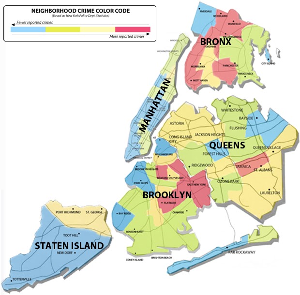
NYC Safety Map for Tourists
Here’s another objectionable one – this one is quite nice cartographically, but what is up with telling tourists that the only safe areas in NYC are the white people zones? 

Manhattan Movie Icons Map
Ok, this one was featured in an earlier blog posting, but I liked it so much, I’m posting it again!  See how many of the movies you can name. See http://geographer-at-large.blogspot.com/2011/05/awesome-nyc-movie-map.html


NYC SitCom Map
From: http://danmeth.com/
One darned funny cartoonist!
NYC Rock ‘n Roll Map

 NYC Superheroes Map


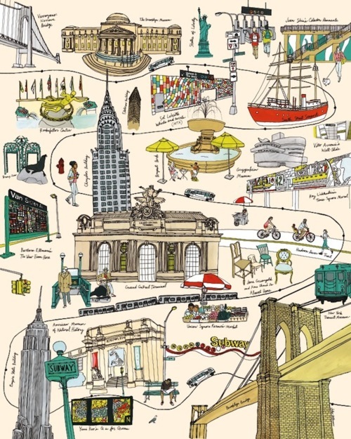
NYC Landmarks Map
See how many you can identify.  The landmark names are written beneath each landmark, but they are a little difficult to read.  See how many you can name without cheating!
 
NYC Literary Map

Bad Stuff in NYC
 Oh, and it’s not all fun and games, movie stars, rock and rollers, and beautiful landmarks!  We have our share of troubles, too: RATS!  BED BUGS!  FORECLOSURES!  HURRICANES!  Potential Terrorist Attacks!

 NYC Rat Map (partial, showing Upper East Side of Manhattan, one of the more "posh" neighborhoods)

 NYC Bedbug Map

NYC Hurricane Evacuation Map - Most of the city is just above sea level, after all! For more complete and up-to-date information about Hurricane Irene and NYC evacuation zones, see August 25, 2011 posting http://geographer-at-large.blogspot.com/2011/08/irene-plans-to-visit-new-york-city-this.html

NYC Foreclosure Map

Detonation Effects Map


Typographical and other Specialty Maps of NYC
And here we have a sub-category of maps made from Typography and other clever methods

Manhattan Map with Neighborhoods Delineated by Type


Typographical Green Spaces Map


Random Typography Map of Manhattan

NYC Cut-out Map (scherenschnitte - scissor cutting style)


Map of the Design Formed by NYC Street Grid, with Interstitial spaces between the streets (the property lots, more or less) re-arranged in a series
«Anagrammes graphiques de plans de villes» by Armelle Caron
OK, you just have to look at this to really figure out what it is.  Pretty interesting and clever.  Check out link below to see other cities: Istanbul, Paris, Berlin, etc.


And here we have a sub-category of Mental Maps of NYC

 This is the famous New Yorker magazine cover, by Steinberg, from 1976, showing a New Yorker’s view of the world.  This cover has been parodied extensively over the years, and has spawned versions purporting to be the view of the world from Irkutsk, for instance. 


This is a recent New Yorker magazine cover, 35 years after the original one, showing New Yorkistan and all the little stans within it.  In the months after 9/11, Maira Kalman and Rick Meyerowitz's ethnic breakdown of the boroughs sold more New Yorker magazines than any other cover in history.


Mental Map of New York, from a native Montanan’s perspective.

Car Tow Story
This is every New Yorker’s nightmare, and even worse for visitors to the city: what happens when your car is towed. It's the 9th Circle of Hell......


Welcome to New York City – a map for some kind of game based on the subway system. 


1950’s embroidered cartoon map showing NYC landmarks.  The attractions outside of Manhattan (Coney Island, Yankee Stadium, Bronx Zoo, LaGuardia Field) are just kind of floating in the East River, and the disembodied bridges go from Manhattan directly into the water..... But hey, at least the map shows Washington Heights and The Cloisters, for a change!

Neighborhoods/Places of Interest Map of (part of) Manhattan
I truly don’t really understand this map.  What are the little faces supposed to denote?  Why are many things in the wrong place?  Why does Manhattan not include Washington Heights and Inwood?  Nevertheless, it is somehow pleasing, graphically. I wonder if the expressions on the little faces are supposed to indicate anything about the areas they are in, like those maps that use Chernoff faces as symbols to depict socio-demographic characteristics.  


Unconventional Maps Exhibit
There was a recent exhibit called “Unconventional Maps” at Pratt Gallery.  You can see some more of the entries at: 
Two examples from the exhibit:

 "The Wonderfulness of Downtown," by Jane Hammond, highlights everyday moments and unnamed streets.

 Artist Liz Hickok, a full-time assistant and several work-study students worked morning til late-evening for 10 days to build "Fugitive Topography: Jelly NYC, View From the Staten Island Ferry."